Wednesday, December 31, 2008

#36 Mesa Verde NP

Mesa Verde is one of my favorite National Parks. It is a series of ancient Indian cliff dwellings located in Southwestern Colorado. A few of the ruins are open to self-guided tours, but the more rewarding experiences are the ranger-led hikes.

The rest of my Mesa Verde Pictures are featured here.

Tuesday, December 30, 2008

#35 Hovenweep NM

Located along the Utah/Colorado border, Hovenweep National Monument preserves five different sites. It is not as well preserved as nearby Mesa Verde, and the smaller amount of visitors make this monument more manageable. This are pictures from the hike to the Square Tower Group near the Visitor Center.

The rest of my pictures of Hovenweep NM are here.

Monday, December 29, 2008

#34 Canyon d' Chelly NM

Canyon d' Chelly National Monument preserves two gorgeous canyons on the Chinle Wash, Canyon d' Chelly (pronounced d'shay), and Canyon del Muerto. The site is sacred to the Navajo and the canyon floor can only be visited on a guided tour or on the strenuous White House Ruin hike. The canyon floor is still used for agriculture. Note the signs advising tourists to take their valuable with them as this park has had lots of problems with theft from cars. This formation is known as Spider Rock.

See the rest of my photos from Canyon d' Chelly NM here.

Sunday, December 28, 2008

The Nut, Tasmania

This is the geological formation known as The Nut, located in Northern Tasmania. The town at the base is Stanley. I rode a chairlift to the top and found it surprisingly full of vegetation. It was also cold and outrageously windy.

The rest of pictures of Stanley and The Nut here.

Saturday, December 27, 2008

Denver

This is a view of Denver from the Rocky Mountains west of the city, taken in 1995, while visiting the area for Kirk and Denise Stueber's Wedding.

Friday, December 26, 2008

#33 Natural Bridge NM

Natural Bridges National Monument is home to three distinct natural bridges, Sipapu, Kuchina, and Owachomo. All have viewpoints and are connected by the 8.8 mile loop. Hikes of varying levels are offered to get closer to the bridges.

Here are the rest of my pictures of Natural Bridges NM.

Wednesday, December 24, 2008

#32 Canyonlands

Canyonlands National Park is located in the same are as yesterday's park Arches. Canyonlands is a large park full of canyons and gorges with the Colorado River running through the middle of the park. Most of the park is only accessible by 4WD vehicle on rough dirt roads.

See the rest of my Canyonlands NP here.

Tuesday, December 23, 2008

#31 Arches NP


Arches National Park is another one of the National Park Systems truely great parks. Despite the variety of amazing rock arches, the park also encompasses desert and mountain landscapes. This formation is known as The Spectacles.

The rest of my pictures of Arches NP are here.

Monday, December 22, 2008

#30 Capitol Reef NP

Capitol Reef National Park encompasses a unique geological feature known as Waterpocket Fold. The park is one of the least heard about and most underrated parks in the National Park System. The area was once settled by Mormon settlers, and many of the building in that settlement known as Frutia still stand today. Also evident are the orchards, which are still maintained by the NPS today.

Sunday, December 21, 2008

Banska Bystrica

This is the main square in the Slovakian town of Banska Bystrica. Our tour group stopped there for a couple hours on our way from Hungary to Poland.

See more pictures here.

Saturday, December 20, 2008

Lindsay's High School Graduation

This is my brother, sister and I at Lindsay's High School graduation in 1998. It is a rare picture of me without the goatee.

Friday, December 19, 2008

#29 Bryce Canyon NP

These are the rock formations known as hoodoos from Bryce Canyon National Park. Bryce isn't actually a canyon, but a naturally formed ampitheater, located about an hour North of Zion NP. The 28 mile scenic drive along the top of the ridge has many spendid viewpoints, and those who hike down into the valley also rave about that experience.

Thursday, December 18, 2008

#28 Zion NP

This is Checkerboard Mesa near the Western Entrance to Zion National Park. Zion is another one of America's premier National Parks. The most popular part of the park is the Canyon created by the Virgin River. There are many spectacular viewpoints that can be reached from easy hikes, but there are also more challenging hikes that await the hearty visitor. One of the NPS' most unique hiking experiences is The Narrows, where you actually hike along a shallow part of the river through a very narrow slot canyon.

Wednesday, December 17, 2008

#27 Pipe Spring NM

Pipe Spring National Monument in Southern Utah was set aside in the 1920 as a memorial of western pioneer life, but the spring and surrounding area have been important to the Native population for hundreds of years before the first settlers from the East. The ancestral puebloans and the Paiute Indians were the first to count on the spring. Later, the Spanish and Mormon settlers also relied on the spring for fresh water in this arid region.

Tuesday, December 16, 2008

#26 Glen Canyon NRA

This is a picture of Glen Canyon Dam, located along the Colorado River, North of the Grand Canyon and near the village of Page, Arizona. The man made lake north of the dam runs into Utah and is very popular with those who enjoy water sports.

Monday, December 15, 2008

#25 Grand Canyon NP

Grand Canyon National Park is one of the gems of the National Park System. It is the second most visited behind Great Smaky Mountains National Park. On my visit in May of 2003, I took a helicopter flight over the canyon. It is one of the most amazing travel experiences that I have had. The overwealming impression looking into the Grand Canyon gives me is how samll we are. My parents first took us to the canyon during the summer of 1982, when I was only 10 years old.

Sunday, December 14, 2008

Nikole & Kathy

These are my friends Nikole and Kathi from Mount Pleasant. They have three awesome dogs, Daisy, Tacoma, and the puppy, Isabelle. Nikole and I worked together at Papa Johns for four years while I lived in Mount Pleasant.

Saturday, December 13, 2008

Dragon Building, Hong Kong

This building was built with the hole in the middle because there is a legend about a dragon that lives on the mountain behind the building. This is located on Repulse Bay.

Hong Kong Pictures- http://www.eriksmith.com/Asia/HongKong.htm

Friday, December 12, 2008

#24 Wupatki NM

Wupatki National Monument is a series of five dwellings built over a thirty mile area. The largest of these dwellings is Wupatki House located behind the Visitors Center. It contains a fascinating ball court, something unique in the dwellings of the Four Corners region. Nearby, a road leads to the dramatically perched Wukoki House. The people who lived in these dwellings were attracted to the area by the fertile farming lands aided by the eruption of the nearby Sunset Crater Volcano. The Mountain seen in the background is Humphries Peak, the highest point in Arizona.

Thursday, December 11, 2008

#23 Sunset Crater Volcano NM

Sunset Crater Volcano National Monument is the cone of a volcano that erupted in 1064-1065 AD. Due to erosion, the cone itself is off limits for hiking, but there is an interpretive trail that leads right up to the base of the mountain, and another trail that leads up a lesser cone nearby. The eruption of the volcano effected Native living for hundreds of years. The hiking trails highlight the unique nature of volcanic areas, much like the ones in El Malpais and Capulin Volcano did.
http://www.eriksmith.com/sw03/sunsetcratervolcano.htm is where to find the rest of my pictures.

Wednesday, December 10, 2008

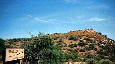
#22 Tuzigoot NM

I visited Tuzigoot national Monument on a blazing hot day in May of 2003. It is a ruin located on a hilltop in the middle of the Verde Valley of central Arizona, just south of Sedona.

For the rest of my pictures from Tuzigoot, click here.

Tuesday, December 9, 2008

#21 Montezuma Castle NM

This is Montezuma's Well, it is part Montezuma Castle NM. It is a natural water hole that the native American population of the area used to satisfy their water needs. It is located eleven miles away from the ruins that are also a part of this monument.
http://www.eriksmith.com/sw03/MontezumaCastle.htm has the rest of my pictures.

Monday, December 8, 2008

#20 Walnut Canyon NM

Walnut Canyon National Monument is located 10 miles southeast of downtown Flagstaff, Arizona. The cliff face dwellings were built here between 112- 1250 A.D. by the Sinaguan. Sinagua is Spanish for 'without water'. They built the one room pithouses (seen in the photos below) to tae advantage of the natural shelter and the water recessed in the limestone walls. It is assumed that these people were assimilated into the Hopi culture. A one mile trail walks around the canyon walls to look the ruins close up.

Here is a link to more pictures- http://www.eriksmith.com/sw03/Walnutcanyon.htm

Sunday, December 7, 2008

Christmas 2007

This picture is from December of 2007, when I came down from Mount Pleasant to visit my nephews, Colin & Eli.

Saturday, December 6, 2008

Athens


This is a picture of the Acropolis complex in Athens. It is taken from one of the other hills in the outskirts of Athens on our December 1999 trip. This, unfortunately, is as close as I got to the actual Acropolis, as I was sick and spent most of this trip in the bathroom or in bed. You can tell by looking at this photo that Athens does not have the highest air quality in the world.

Friday, December 5, 2008

#19 Hubbell Trading Post NHS


John Lorenzo Hubbell was a trader whose friendly relations with the Navajo made him a southwest legend. The Trading Post and many of it's other buildings are preserved today. The Trading Post still sells things it sold in Hubbell's day, Indian Jewelry and Rugs, and well as modern things like souvenirs and candy. The day I was there it was overrun with school groups, so I didn't stay long inside the packed Trading Post. Hubbell is reported to have been buried in the Navajo tradition, in a unmarked grave, on the hill behind the site.

http://www.eriksmith.com/sw03/HubbellTP.htm

Thursday, December 4, 2008

#18 Petrified Forest NP


Petrified Forest National Park is two parks in one. Most of the Southern half is the Petrified Forest (bottom picture), which contains lots of different pieces of Petrified wood, the largest such collection anywhere is the world. The Northern Part of the park is the fantastic and beautiful Painted Desert (top picture), which stretches northward toward the Navajo Indian Reservation.

Both parks are featured here-http://www.eriksmith.com/sw03/PetrifiedForNP.htm

Wednesday, December 3, 2008

#17 El Morro NM


El Morro National Monument is a huge sandstone bluff that stands out in the desert and so has attracted people for centuries. The ancient decedents of the Zuni called this area home over 1,000 years ago. The Spanish are responsible for the earliest dateable inscriptions on 'Inscription Rock', and the Americans also carved their names on the rock, as the young country expanded westward. El Morro is Spanish for 'The Headland'. Today, inscriptions are visible on the rock from the easy loop trail that circles the front of the rock. A longer two mile trail leads to Indian Ruins on the other side of the Rock.

This carving in the rock is that of an two army men, one from North Carolina and one from Michigan. Lieutenant Breckenridge would die a few years later in the Civil War.

The rest of my pictures are posted at http://www.eriksmith.com/sw03/elmorro.htm.

Tuesday, December 2, 2008

#16 El Malpais NM


El Malpais National Monument is Western New Mexico is a large area of lava flows, pine forests and lava tube caves. The name comes from the Spanish for "badlands", and today the area is popular with both hikers and rock climbers.

See my very limited set of photographs at http://www.eriksmith.com/sw03/elmalpais.htm.

Monday, December 1, 2008

#15 Bandelier NM


Bandelier National Monument is named after Adolph Bandelier, a anthropologist who is said to have first reported the dwellings here. The park is 40 miles west of Santa Fe, New Mexico. Most of the dwellings are located in Frijoles Canyon, a lush canyon set against the Jemez Mountains. The site is important to the Native history, as it was occupied for over 500 years and some of the other cultures such as those from Mesa Verde and Hovenweep may have migrated south to here. The dwelling was also populous, holding as many as 40 families at one point in time. I took the Frijoles Canyon Trail, which followed a cliff side path through the remnants of this society. It is not even as close to as well preserved as Mesa Verde, so understanding it's importance in history is important.

See the rest of my pictures here- http://www.eriksmith.com/sw03/bandelierNM.htm

Sunday, November 30, 2008

Grand Teton September 2001

Keath, Tone and I went to Yellowstone and Grand Teton National Parks in September of 2001.

Saturday, November 29, 2008

Dad & I on TV

This is a picture of my dad and I at the Michigan State - Wisconsin-Green Bay game in December of 2007. I took this picture of the TV screen to show how close we were to the floor. The camera could see us almost every time it panned over to the Michigan State bench.

There are more photos from this cool experience here.

Friday, November 28, 2008

#14 Pecos NHP

Pecos National Historic Park is located on a stretch of land where people have lived since 800 A.D. The Pecos Pueblo became a very large city in the period preceding Spanish arrival in the Southwest. Coronado made his way through Pecos looking for riches. A Puebloan guide was given to him, but led his men onto the great plains hoping they would die from heat and starvation or at the hands of the Apaches. Coronado returned and wreaked havoc on the people of Pecos. Next came the Missionaries. The Mission dates from an exceptionally aggressive period of mission building in the southwest, in the early 1600s. The over zealous Spanish did not succeed in their conquest of the Puebloan People, but Pecos was deserted by the 1830s, with the last people moving north to Jemez Pueblo.

See the rest of my photos here.

Thursday, November 27, 2008

Happy Thanksgiving!!


I figured today I would publish pictures of the things I am most thankful for.

Wednesday, November 26, 2008

#13 Fort Union NM

Fort Union National Monument stands on a site where three separate forts once stood. The first, of which nothing remains, was a sloppy mud fortification built to protect the early settlers of New Mexico from Indian raids. The second fort also was built with that purpose in mind, but served as a staging ground for the most important battle in the Southwestern theater of Civil War, The Battle of Glorietta Pass. The third fort was an adobe and brick fort, but even it had outlived it's usefulness when it was abandoned in the 1890s in favor of newer and more centrally located defensive posts.

See the rest of my pictures here.

Tuesday, November 25, 2008

#12 Capulin Volcano NM

Capulin Volcano is a perfectly formed cinder cone volcano that rises on the Raton-Clayton Volcanic Field of Northeastern New Mexico, which contains about 120 volcanic formations total. I walked around the rim on a paved trail on a glorious morning in May of 2003.

See the article and more pictures at the Capulin Volcano NM page on my website.

Monday, November 24, 2008

#11 Bents Old Fort NHS

This was my first stop on my Southwest 2003 trip. It also has the distinction of being the first National Park Site that I visited after deciding to try and visit all of the units that spring.

This fort, located in Eastern Colorado, next to the Arkansas River, was an important stopping point for travelers along the Santa Fe Trail from Missouri to New Mexico in the 1830-50s. Founded by brother Charles and William Bent, and their statesmen partner Ceran St. Vrain, the post was a meeting point for the Native Americans, road weary Pioneers, and the Spanish from the South.

See my Bent's Old Fort NHS page on my website for more pictures and the complete article.

Sunday, November 23, 2008

Nha Trang Market

This picture was taken in a market outside of Nha Trang, Vietnam in 1996. The people in Vietnam were poor but very friendly. The food was also very good, but you could not tell it by looking at this picture.

http://www.eriksmith.com/Asia/nhatrang.htm
has the rest of my pictures from this stop.

Saturday, November 22, 2008

Camp Arcadia Staff 1994

This is a photo of most of the staff of Camp Arcadia for the summer of 1994. I was lucky to spend two of the most outstanding summers of my life working with an amazing and talented group of people.

Friday, November 21, 2008

#10 Dry Tortugas National Park

Located 70 miles west of Key West, Dry Torugas National Park contains Fort Jefferson, a Civil War era fort bulit to defend the Mississippi River Watershed, and a number of coral reefs popular for diving and snorkelling. The fort never saw any action and is most famous for being used as a prison to house Dr. Samuel Mudd, the surgeon who repaired the leg of John Wilkes Booth, the assassin of Abrham Lincoln. This is such a unique park in a unique setting, it is one of my favorites. It is accessable by boat and seaplane from Key West.

See more pictures from January 2003 when I went with my mom, dad & sister-
http://www.eriksmith.com/Florida03/DryTortugasNP.htm

Thursday, November 20, 2008

#9 Everglades NP


Everglades National Park in Southern Florida, preserves North America's largest and most important wetlands. It is a small section of an ecosystem that used to encompass almost the whole Southern half of Florida, an area that has lost at least half of it's size due to spreading urbanization and draining for farmland. It is a prime birding and wildlife viewing spot and home to a very small number of the very endangered Florida Panthers. The highlight for me was seeing all the exotic birds, plus the alligators. The top picture is of the Pinelands area of the park. These small pockets have been especially hard hit by the eroding of this once pristine environment.

See more pictures here-(this is a park I intend to re-photograph while visiting my parents one of these years) These pics are from January of 2003, while on my way to Key West.

Wednesday, November 19, 2008

#8 DeSoto NM

De Soto National Memorial, 5 miles (8 km) west of Bradenton, FL, commemorates the 1539 landing of Hernando de Soto and the first extensive organized exploration by Europeans of Florida and the Southeastern US. DeSoto's leagacy, like many of the early explorers, is checkered with abuse of the native population spurred on by greed.

See More of my pictures from January 2003 here-
http://www.eriksmith.com/Florida03/DesotoNM.htm

Tuesday, November 18, 2008

#7 Father Marquette NM

Father Marquette National Memorial in located near the straits of Mackinac and the Mackinac Bridge connecting Michigan's Upper and Lower Peninsulas. This memorial commemorates Marquette & Joilet's 17th century exploration on the Great Lakes area. Marquette is also responsible for establishing the nearby town of St. Ignace, as well as the town of Sault St. Marie, where the Soo Locks are now located. This is technically not a National Park, but it is an affiliated area.

Monday, November 17, 2008

#6 Pictured Rocks NL

Located on the Lake Superior shore in the Upper Penninsula of Michigan, my home state, Pictured Rocks National Lakeshore is a popular place to take boat tours to view the rocks from the water. The park is also home to numerous waterfalls and hiking trails. This formation is called Miner's Castle.

Here are the pictures from the summer of 2002, the last of my three visits to this park-
http://www.eriksmith.com/UP02/PicturedRocksNL.htm

Sunday, November 16, 2008

Waldenbooks and the Deathly Hallows

This is the crew I worked with at Waldenbooks in Livonia for three months last year. This picture is from our midnight party for the release of "Harry Potter and the Deathly Hallows" on July 21st.
http://www.eriksmith.com/Professional/waldenbooks.htm has the rest of the pictures from that night.